
It was September of 2012, and a run of near perfect weather gave rise to the idea of climbing Mt Gillespie, in the Mamquam River Valley. It’s a handsome peak, surrounded by dwindling pocket glaciers, and lies in a remote part of Pinecone-Burke Provincial Park. So it was that Ted and Denis, also known as “The Retreads,” and I were rolling up Highway 99 at an ungodly early hour. Soon, we turned into the shadows cast by the sheer walls of the Squamish Chief, and from there, we would need to travel quite some time on logging roads to reach our destination.

But… “Whoa now, wait a minute!” You’re thinking. “What the heck is a retread?” Well, it’s a term that is, as far as I know anyway, previously coined by my longtime trail companions. Denis describes a retread as a grizzled, old school, experienced mountain man who drinks beer, likes to joke, and never gives up till the job is done. There’s also an aspect of style to the term, in that retreads do not resemble today’s metrosexual genre, per se. As I’m fourteen years their junior, I’ve sometimes been called a “pretread”, or a retread in training, if you will. I also get to be the expedition photographer because, as Denis says, “Why would I carry a camera when you have one?”
These two guys have known each other almost as long as I’ve been alive, and their long history makes for a wealth of experience and plenty of laughter, as I’m sure you can imagine. The tall tales were flowing freely that morning, so much so that we managed to miss the turnoff for the road we needed. Instead, we ended up inadvertently exploring some newly cut logging spurs. After that idle distraction, we then had to double back and recross the bridge we had passed, thus wasting about half an hour. I was unperturbed by the delay, probably because it just gave me more time to hear their lively banter!
At some point on the long drive, it occurred to me to ask Ted what the heck the clinking sounds coming from the back seat were. He informed us insistently that some of the beer he’d brought had to be consumed from “proper glasses.” This was a first for our trips, though we later discovered that glass and logging roads make uneasy partners. When I chided Ted about whether he’d next be bringing limes on trips he assured me that would not be happening. “Old school climbers don’t put lime in beers, and they don’t stretch before the hike either!”

Tom Fyles, above, was an old school, hardscrabble British Columbia climber also known as The Climbing Postman, and one of Ted’s all time favourites. Ted always assures me Tom neither stretched nor did he ever put limes in beer!
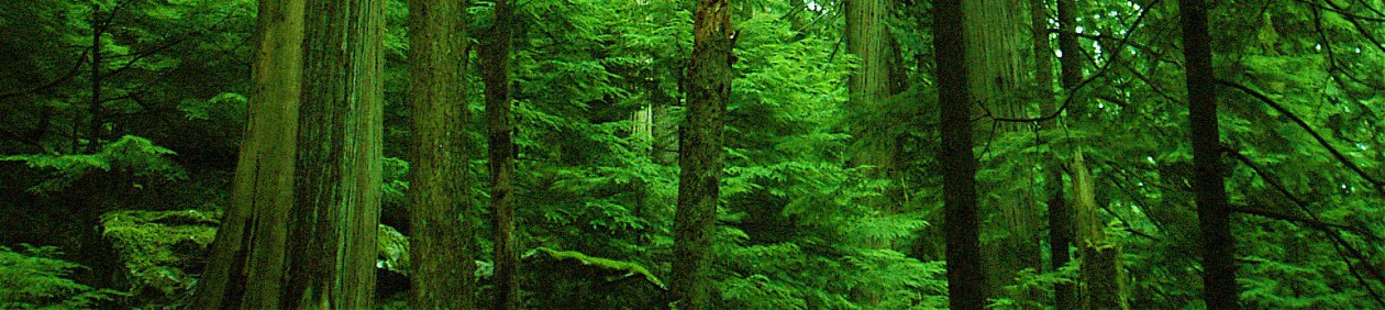
Two hours passed before we finally reached the trailhead. I had been there several years before, and immediately noticed that alder had reclaimed some sections of the road, but at least the water bars remained only a mild deterrent. We geared up, and began forging our way up the rough forest in the lower cut block.

To my chagrin, I noted that the forest had now been marked as a logging boundary (but as of 2016, it still has not been harvested). Losing those trees would be a shame, as the old growth mountain hemlock forest makes for a scenic walk, en route to the meadows.

The way to Gillespie is relatively straightforward. First you must attain Peak 5700 from the top of the proposed cut block, and then you need to lose elevation into a gap, before ascending to the alpine basin below Peak 6500 (sometimes known as Seed Peak). From there you wind your way through the ancient glacier that will yield the ridge leading to Gillespie’s summit, at 2018 metres in elevation. There are amazing sights in all directions as soon as you gain the plateau below Peak 5700.
You’ll note in this tale I sometimes refer to elevations in both feet and metres, so I apologize for the confusion. Ted and Denis are only reluctant converts to the metric system, and would be quite happy sticking to English measures. Being typically Canadian, I try to appease all parties!


After a mere half hour of trekking, we climbed a steep hillock that gave us access to the summit of Peak 5700. It was an ideal vantage point, from which we caught the first glimpse of our objective.
This valley has become a welcome place to me, despite my indoctrination to the region some years back with my good friend Chris B. That had been a day of foul weather and fleeing from bears, to exaggerate only mildly. Later that same year, Doug and I returned to climb Peak 6500, a more memorable occasion! The previous excursions I had made there had given me a sense of familiarity, but more than that, the area has always seemed pleasant in nature to me. It’s hard to explain, almost as though there are good vibes there, or something like that.


There were only mild technical difficulties on the next leg of the trip. The trail, if you can call it that, simply uses a high connecting bench that leads you to slopes below Peak 6500. Then, once you manage to arrive in the high alpine bowl above, you can plot your route to Gillespie.

For a number of years I have wanted to do spend a weekend here, as it has all the amenities of a fine wilderness basecamp. There is abundant drinking water, and a few icy tarns to cool you off on those hot summer days. The retreads, though, abhor overnight missions, preferring marathon marches, if necessary, to finish in a single day.

Challenges would soon begin in earnest, however. Crossing the bench proved simple enough, but meandering down the granite slabs into the belly of the pocket glacier was somewhat more difficult.
The glacier has receded considerably, and there were no crevasses to contend with. There were dangerous moats where ice had melted away from the rock faces, so those had to be carefully avoided.


I am pretty sure this was the friendliest glacier I have ever hiked. The snow was in ideal condition and was never steep enough to require crampons. We simply strolled across it.

In the now approaching midday sun, the rock took on different tones, changing from polished greys to browns and pinks.

The glacial ice, too, was fascinating. You can see(photo above) that concentric patterns have formed, over the years. I’m not totally sure how that process would have occurred, but it was fascinating to observe.

I had first heard of this mountain years before from good friend Simon, who had climbed it back in 2005, and his description of the route was quite accurate. We just climbed up to a broad ledge that gave way to a steep and somewhat loose section of scrambling. This was the key that unlocked the ridge. We marked our exit point with a cairn so as to make the trip back less complicated, or so we thought.

The bottom of the ridge consisted of fairly simple hiking, with the odd bit of boulder hopping thrown in. The ground here could aptly be described as alpine rambling, according to Ted.

Once through a large rock garden, we broke into the clear and were able to see the summit block. It was hard to evaluate the crux from where we stood, but as Denis often says “You’ve got to get a closer look to be sure, it never looks easy from afar.”

What next? Eyeing the summit from the clearing, I figured on a short walk on the snow to begin with, and then we could stick to the rock from then on.

The rocky field of boulders below the buttress above posed no issues at all. It wasn’t long after that we found ourselves gazing at the last of the obstacles keeping us from the summit. A short snowfield loomed ahead, with promising views!

What was even better was that the views opened up more with every step we took. The Mamquam Vallley is a sight to behold, highlighted by glacier clad Mamquam Mountain, which lies within Garibaldi Provincial Park. When we crested the boulder slope, we could see a very nice line up a snowfield that had remained hidden until then. Denis now led the way, beneath the warming the rays of the sun.

That anticipated crux turned out to be narrow slot with almost no exposure that could be scrambled with ease! That completed, all that was left was to tag the summit.

It was time to break for lunch and enjoy the fine views afforded by the summit. But first, a bit of historical banter…

Ted, as it turned out, had worked with John Gillespie, whose father had been instrumental in lobbying for Pinecone-Burke to be set aside as parkland. The elder Gillespie had passed some years ago, but the mountain we stood atop had been named in his honour. (Edit here: I was incorrect with this information when I published this story in 2019. The elder Gillespie actually passed away in late June of 2021, according to his son, who contacted me in the summer of that year). A worn but well made little sign lay nearby as well. Enjoy the summit views as we saw them that day!

There was a large snowfield and a glacier on the other side of the mountain, which I had been unaware of. Compared to the pocket glaciers on our approach, it was surviving quite well.

Haze from recent forest fires hung over the mountains, but of course the views were still grand. The remote spires of the Five Fingers Group were on prominent display.


Of course, we couldn’t stay there forever, because lingering on mountaintops more than thirty minutes is frowned upon in the retread culture. I suspect this is mainly because the cold beer is back at the truck and, well, that reason’s good enough for me!


The plan was, of course, to retrace our steps from whence we came, but on the way back we somehow missed the conspicuous cairn Denis had placed, and ended up casting about for alternative routes down to the glacier.


The sight of November Lake brought to mind my friend Martin. He has a burning desire to pack inflatable rafts up to alpine lakes, and I think he has his eye on this jewel too!

We explored several routes downward. One was a steep gully that looked loose and unsafe, so that was ruled out, as were two more that ended in cliffs. We were about to reluctantly climb up and search for the cairn we had missed when Ted noticed a rocky gully that swung down to a moraine we could cross to get closer to the glacier.


Attaining the glacier was still somewhat tricky, as there were moats to contend with, but finally an easy avenue appeared. We crossed the glacier once more, aiming again for the basin below Peak 6580 .


Under ideal conditions, but as dictated by the objective, one of the chief designs of a retread’s day in the hills is to avoid vertical gain on the trip back. That was not possible on this day, as the ups and downs of these mountains meant there’d definitely be some hard work on the way home. Once at the basin we met some hikers with their dog who had climbed Peak 6500. I jokingly asked them if they had found the pair of sunglasses Doug had left there when we had visited back in 2007, but no luck there. Somewhere there’s a mountain goat strutting the hills there with a nice pair of shades, looking cool, I suppose.

The walk back up to Peak 5700 after descending the ridge below Peak 6500 was a bit of a chore for me. I’m not sure whether I managed to get dehydrated or what, but I ended up with a sore quadricep for a week after this trip. We were all happy to make it back to the truck and down a few very cold Budweisers after roughly 7 1/2 hours on the trail. Retreads in training are also required to supply chips, plain or ripple but no flavours being preferred. A very rewarding day, good times!

Myriad topics of conversation on the drive home included mountains, more mountains, wine, women, song, still more mountains, barrroom brawling, the NFL, softball, old western movies, beer, chips, more beer, and still more beer.
Since the ride up had thoroughly shattered his beer glasses, Ted included one of these beers below to each of us as parting gifts. Add a total of 5 1/2 hours driving- longer still for the guys- and it made for a solid 14 hour day. If you have never visited this part of the Coast Mountains, you’re missing out on the sublime experience that is the Mamquam Valley. Get up there soon!


That really looks like a great hike! What a view, and amazing pictures!
LikeLike
It sure was. Definitely among my all time favourites 🙂
LikeLiked by 1 person
Amazing photos
My father passed only today
He was the greatest father and hero and forever helped teach us about the wonders of the wilderness and the goodness in all who wandered about: Never loss, just misplaced
jg
LikeLiked by 1 person
Sorry for your loss, John. Teaching others about wilderness is one of the finest gifts anyone can give.
LikeLike
John, can you confirm for me that the mountain was named after your dad? Just was curious as to the details involved as it’s quite unusual to have a peak named for you when you’re still alive. My eternal gratitude to him for helping to make that area parkland, it will always be a place close to my heart
LikeLike